.jpg)
Well there is this one site tackamarks.freeservers.com about the secret codes in our road signs. This site has been archived but you can still click on the link to see a version of the original site.

Embedded in our nation’s road sign system is a secret coding designed to target vital sites, facilities, routes and resources for military confiscation during a National Emergency. Though, concealed by the lies of the Department of Transportation for many years, “Free Indeed Research” has tapped deeply into one of the most clever, and deceptive cover-up operations to come down the pike in years! (If you think GPS will be working normally in the scenario described above, think again.)
The United Nations military has plans to become the cop soldiers of the world. Unknown to the general populace, a “Rapid Deployment” force stands ready to enter U.S. borders at the request of the President of the United States during a national emergency. They will perform “peacekeeping” operations such as evacuations, rounding up dissenters, confiscating firearms and incurring facilities and sites for military use. These forces are laced with foreign troops that do not speak English. Therefore, as a tactical advance, all nations have been secretly revamping their roads sign systems to conform to an international standard under the guise of the WTO. It is our belief that these signs and reflective markers “TACMARS” on the backs of many signs are coded to target vital sites, facilities and resources to be confiscated and used by these troops.
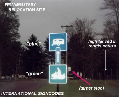
How the quadrant sign codes works:
1. Signs are divided in half, left and right.
2. Markers positioned on the right side, point right.
3. Markers on the left side, point left.
4. Markers turned on “end” are an arrow “UP” code, signifying a site for pick-up helicopter airlifts
5. Marker on top means straight ahead
6. Double ended arrow denotes an airlift facility
7. 3 arrows denotes a facility
8. 2 arrows denote the direction of the operational site
9. The coding on the stickers is also used to point to drugstores with passport photo services. Under martial law, this facility may be used for medical care, inoculation/vaccination, and creation of ID cards.
Tacmars’ are used to encode the following:
* Directions to closest military installations
* Directions to closest triage or quarantine facilities
* Facilities with Internet access, for the following purposes: Communications Identification and/or background search of individuals
*Directions to closest detention facilities
* Directions to closest triage or quarantine facilities
* Facilities with Internet access, for the following purposes: Communications Identification and/or background search of individuals
*Directions to closest detention facilities
In-case this is a true conspiracy, you can easily trick the military by using fake marks or even byremoving these Tacmars symbols. “For many years now, under the guidance of federal and local managers, every city, town and village in the U.S. has been covertly set up by manipulating and using our sign system to target and mark vital sites, facilities and resources for confiscation and seizure by the military.” Even when they were in the Middle East these Tacmars were used by all the different military’s as stated below by a NAVAL CHIEF PETTY OFFICER..
‘While I was stationed in Beirut, Lebanon after the bombing in the 80′s, I saw those markers (tacmars) put on the back of their roadsigns to bridge language barriers among multinational peacekeepers doing military operations in the city.’ (CPO A.Phillips U.S.N.)I also seen this one the other day, it was a sign pointing to the Courthouse and it had a question mark on it…?! We have seen lots
of signs that confirm the configurations are not just random, but are part in a clever directional system called “TACMARS” (“tactical markers”) a code system for military use. So are they used by UN Peacekeepers, Our Military, Soon to be Martial Law, or Nuclear War? The real question is who decides to spend the money and the time to map out towns and cities for a future “disaster.” The MILITARY! They will be the ones that will be putting the citizens in (FEMA) concentration camps.. The government has so many executive orders that “allow” them to control all the major necessities like communications, food, travel and much more.. No Rule of Law… No Rights… And No Way of surviving… These Tarmacs are real and they are for official military use. Which makes it really scary and real that something is going to happen real soon. Share this with your friends and family, people need to know about this.. Keep your eyes open!
